Delineation and Characterisation of the Crater Watershed Using GIS
DOI:
https://doi.org/10.47378/h2532920Abstract
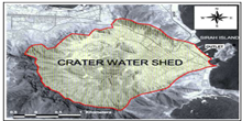
The Geographical Information System GIS have been utilized to delineate and characterize the watershed of the historical city of Crater (Aden). Satellite imagery, remote sensing digital elevation data, and available old maps of storm water system have been combined together to produce a physiographic definition of the watershed in a form ready for integration with the hydrological characterization to construct a numerical watershed model that can be used to estimate the storm runoff volume and hydrograph at any location in the watershed.. This paper also highlights the ancient advanced hydrological knowledge and sophisticated flood training, detention and
storage engineering works present in the Aden historical drainage system.
1. INTRODUCTION
Over the last three decades, a number of computer based hydrologic simulation models have been developed to simulate the rainfall-runoff processes. Singh and Woolhiser [2002] provide a comprehensive list and discussion of the numerous models available. Physically-based hydrologic models are based on an understanding of the physics of the hydrologic processes that control watershed response by accounting for all runoff components and emphasizing an over-all moisture balance within the basin [Nicklow et al., 2004]. Earlier, such models were considered to be too computationally and data intensive to use for projects other than major research undertakings or large-fund projects. However with the present advancement in geographical information systems (GIS), remote sensing and satellite imagery and computational capabilities of personal computers, physically-based models have become the standard tool of watershed or basin management. Input data required by such models could be easily obtained from satellite imagery and remote sensing as will as traditional database and engineering drawings using standard GIS software like the Environmental Simulation and Research Institute (ESRI) ArcGIS® or ArcView. Most of the models nowadays are GIS enabled or can be integrated with GIS software which facilitates input data and output results management.
Downloads
References
Ali, A Y., 1997. Sewerage and Storm Water Drainage System of Crater,
UNESCO/UNDP Proj. Rehab. Of Taweela Ancient Water tanks, Aden, Yemen.
Huber, W.C., and R.E Dickinson, 1988. Storm Water Management Model, Version 4,
User’s Manual, EPA/600/3-88/001a, US Environmental Protection Agency,
Athen, GA, USA.
Hydrologic Modelling Centre(HEC), 2000. Hydrologic Modelling System HEC-HMS
User Manual, US Army Corps of Engineers, Davis, CA, USA.
Nicklow, J.W, P.F. Boulos and M.K. Muleta, 2004. Comprehensive Sewer Collection
Systems Analysis Handbook for Engineers and Planners, MWH Soft, Inc.CA,
USA.
Norris, H.T. and F.W. Benney, 1953. An Archeological Historical Survey of the Aden
Tanks, Hodgson &Sons, London, England.
Delineation and Characterisation of the Crater Watershed… / Yemen Engineer Vol 6 (2006) 69
Singh V.P. and D.A. Woolhiser, 2002. Mathematical Modeling of Watershed
Hydrology, J. of Hydrologic Engg., ASCE, Vol. 7 no. 4, 270-292.
Soil Conservation Service (SCS), 1965. Computer Model for Project Evaluation,
Technical release No. 20, US Department of Agriculture, Washington, DC,USA.
Soil Conservation Service (SCS), 1985. Urban hydrology for Small Watersheds,
Technical release No. 55, US Department of Agriculture, Washington, DC,USA.
Woolhiser, D.A., R.E. Smith and D.C. Goodrich, 1990. KINEROS – A kinematic
Runoff and Erosion Model: Documentation and User Manual, Rep No. ARS-77,
US Department of Agriculture, Washing.
Downloads
Published
Issue
Section
License

This work is licensed under a Creative Commons Attribution-NonCommercial 4.0 International License.
This work is licensed under a Creative Commons Attribution-NonCommercial 4.0 International License.